Back To The Future Of William Smith’s Map – Meeting Modern Needs For Geological Knowledge
Andy Howard (British Geological Survey, Keyworth)
This year, 2015, marks the 200th anniversary of William Smith’s famous geological map of England, Wales and part of Scotland. The first national map of its kind ever to be published, it set a template for geological maps that remained largely unchanged until the start of the 21st century.
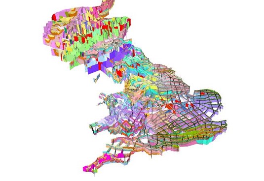
William Smith used observations from mines, rock outcrops and the general shape of the landscape to assemble, in his mind, a fully 3 dimensional understanding of the geology and stratigraphy of the rocks beneath our feet. The paper map was the best available technology at the time to communicate this understanding to his fellow scientists, and to the engineers and miners who needed this knowledge to build and fuel the industrial revolution. His other outputs, notably his cross-sections, strati graphical tables, memoirs and texts, demonstrated an extraordinary vision of how to organise and communicate geological knowledge and are the direct precursors of the geological information systems of today.
Modern geologists are similarly challenged to provide the essential knowledge needed for secure energy and water supplies, critical mineral resources, and a safe and sustainable environment. This talk will highlight the challenges that will motivate the William Smiths of tomorrow, and the tools and technologies they will use to map and model our subsurface environment in a rapidly changing world.